Menu
- Home
- Search▼
- List▼
- Add▼
- My Relate▼
- Admin▼
ViewsWatchers |
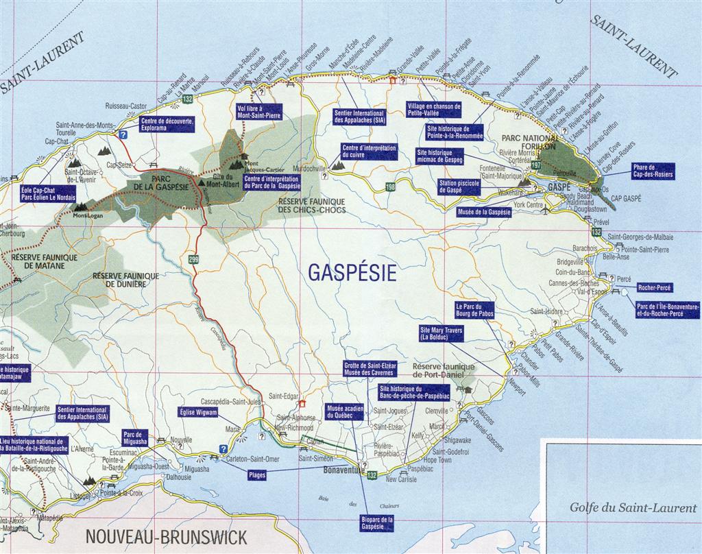
Gaspé is now a "city" at the tip of the Gaspé Peninsula in the Gaspésie–Îles-de-la-Madeleine region of eastern Québec, Canada. Gaspé is located about 650 kilometres (400 mi) northeast of Quebec City, and 350 kilometres (220 mi) east of Rimouski. As of the Canada 2011 Census, the city had a total population of 15,163. Immediately south of the easternmost point of the peninsula, is a broad river mouth or estuary leading into the Gaspe River. This has been the centre of Gaspe ever since explorer Jacques Cartier halted in the bay after losing an anchor during a storm in 1534. He claimed possession of the area by planting a wooden cross with the king's coat of arms and the sentence Vive le Roi de France (meaning "Long live the King of France"). Cartier met there an indigenous tribe that referred to the territory as Honguedo, probably a Mi'kmaq word meaning "meeting place". In addition to the city, Gaspé's boundaries stretch to the communities of Cap-aux-Os, Cap-des-Rosiers, Douglastown, Haldimand, Jersey Cove, L'Anse-à-Fugère, L'Anse-à-Valleau, L'Anse-au-Griffon, Penouille, Petit-Cap, Petite-Rivière-au-Renard, Pointe-Jaune, Rivière-au-Renard, Rivière-Morris, Sandy-Beach, Saint-Majorique, Saint-Maurice-de-l'Échouerie, Wakeham, and York Centre. The city's territory occupies 1,440 square kilometres (560 sq mi) and borders the sea and the St. Lawrence River for some 130 km (81 mi). French is the first language learnt by most of Gaspé's population where nearly 90% of the population is French Canadian. For a diagrammatic map of the current extent of Gaspé, see Wikipedia.
[edit] HistorySoon after Jacques Cartier's discovery of Gaspe Bay and the prevalence of fish in the area, French-speaking settlers from France and the Channel Islands began to establish habitation there. Following the Treaty of Paris in 1763, British officers and soldiers acquired free land in Gaspé. In 1784, they were joined by many Loyalist settlers moving north from the newly-formed United States. From then on, Gaspé became an important commercial fishing centre, especially of cod. In 1804, its post office opened. In 1833 in Gaspé County there were only ten farmers, all in the Gaspé Bay area (of whom seven were also involved in the fishery), four whalers in Gaspé Bay, five shipbuilders (one a Jersey firm from the English-owned Channel Islands), one blacksmith, two lumber merchants, five shipowners (all of which were Jerseymen), eighteen fish merchants (of whom all but five were Jerseymen) and thirty-two major fishing establishments (of which sixteen were Jersey owned). Gaspé was incorporated as a village municipality in 1855. From 1861 to 1866, the port of Gaspé was a duty-free port, making shipping the primary economic activity. With some 40 to 50 European ships docking annually, many countries opened consulates in Gaspé, including Italy, United States, Brasil, Portugal, and Norway. By 1911, the railway reached Gaspé. But the town's ambition to become an international shipping and transportation hub ended with the growing importance of the Montreal and Halifax harbours. During World War II, some 3000 soldiers were stationed at a naval base built at Sandy-Beach to patrol the Gulf of Saint Lawrence against German submarines. In 1959, Gaspé gained city status. In 1971, the city was greatly expanded when it amalgamated these 11 surrounding municipalities (with year of original incorporation):
In subsequent years, the city's area was further expanded by absorbing large tracts of adjacent unorganized territory. [edit] Research Tips[edit] Census[edit] Maps and Gazetteers
[edit] French names for placesBecause French is the one official language of Québec, WeRelate employs the French names for places within the province. Many placenames will be similar to their counterparts in English, with the addition of accents and hyphens between the words. The words "Saint" and "Sainte" should be spelled out in full. Placenames should be made up of four parts: the community (or parish, or township, or canton), the historic county, Québec, Canada. You may find placenames red-linked unless you follow these conventions. [edit] Local government structureThe Province of Québec was made up of counties and territories. Counties in Québec were established gradually as the land was settled by Europeans. Each county included communities with some form of local governement (often church-based). Territories referred to the undeveloped sections under the control of the government in charge of the whole province at the time. The communities included townships and/or cantons, depending on the English/French makeup of the county concerned, and also included ecclesiastical parishes with somewhat different boundaries which could overlap with local townships or cantons. Ecclesiastical parish registers have been retained and are available to view (online through Ancestry). Since the 1980s many small townships and parishes are merging into larger "municipalities", often with the same name as one of their components. Beginning in 1979 the historic counties of Québec were replaced by administrative regions and regional county municipalities (abbreviated as RCM in English and MRC in French). Regional county municipalities are a supra-local type of regional municipality, and act as the local municipality in unorganized territories within their borders. (An unorganized area or unorganized territory is any geographic region in Canada that does not form part of a municipality or Indian reserve. There is a list in Wikipedia.) There are also 18 equivalent territories (TEs) which are not considered to be RCMs. These are mostly large cities with their suburbs, but include 4 very large geographical areas where the population is sparse. The administrative regions (above the RCMs in the hierarchy) are illustrated on a map in Wikipedia. The regions are used to organize the delivery of provincial government services and there are conferences of elected officers in each region. The regions existed before the change from historic counties to regional county municipalities. The above description is based on various articles in Wikipedia including one titled Types of municipalities in Quebec NOTE: WeRelate refers to Québec communities as being within their historic counties because this is the description which will be found in historical documents. FamilySearch and Quebec GenWeb follow the same procedure. However, it is always wise to know the current RCM as well in order to track these documents down in local repositories and also to describe events which have taken place since 1980. Because the former or historic counties and the modern regional county municipalities can have the same names but may cover a slightly different geographical area, the placenames for Regional County Municipalities or "Territories Equivalent to regional county municipalities" are distinguished by including the abbreviation "RCM" or "TE" following the name. Historic counties (which were taken out of use in about 1982) were made up of townships or cantons. The two words are equivalent in English and French. Eventually all the Québec cantons in WeRelate will be described as townships. Many townships disappeared before 1980 with the growth of urbanization. If the word parish is used, this is the local ecclesiastical parish of the Roman Catholic Church. Parish boundaries and township or canton boundaries were not always the same. The WeRelate standard form for expressing a place in Québec is township/canton/parish, historic county, Québec, Canada,
[edit] Other Sources
|
||||||||||||||||||||||||||||||
