Menu
- Home
- Search▼
- List▼
- Add▼
- My Relate▼
- Admin▼
ViewsWatchers |
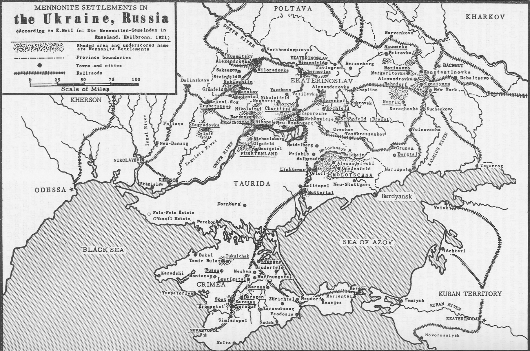
Map: http://www.krausehouse.ca/krause/images/1921UkraineMennonites.jpg
The villages of Chortitza and Rosenthal were settled in 1789. The church, administrative offices, flour mills, machine factories and secondary schools were located there. The old oak tree in the village of Chortitza provided shelter for some of the first Mennonite emigrants from the Vistula Delta in 1789. Because of its great age and unusual shape, the Zaporozhian Cossacks who lived in that area till 1774 considered the oak to be sacred. The practice of worshipping an oak tree was a carry-over from pre-Christian times (988 A.D.) when Slavic people worshiped Perun and Svantovit. This magnificent oak, was till recently, a natural monument protected by the state and a popular tourist attraction. The tree has a height of thirty-six metres (115 feet), and the crown has a diameter of forty-three metres (137 feet). The age of this tree is estimated to be seven hundred years. The shape of its leaves is very similar though slightly smaller than the leaves of the burr oak common in Manitoba. Today, however, the tree is in the process of dying. In 1994 there was only one green branch left on the tree.
Chortitza Colony (p. 41,42) (http://en.wikipedia.org/wiki/Khortytsia) (http://en.wikipedia.org/wiki/Zaporizhia) (http://en.wikipedia.org/wiki/History_of_Zaporizhia) Chortitza also known as the Old Colony was settled in 1789. The colony consisted of eight villages at first. New tracts of land were purchased as more families arrived from Prussia. By 1824, the colony had expanded to include eighteen villages. Kronsgarten, not shown on this map, was located near Ekaterenaslav about sixty-five kilometres north of Chortitza. In 1916 the German colonists sold Khortytsia Island to the Olexandrivsk (Alexandrovsk) city council (see Chortitza Colony) History of Zaporizhia Before 1770: Zaporizhia 1770- 1921: Fort Alexander, Alexandrovsk 1921-: Zaporizhia Bergthal Colony (p. 123) http://en.wikipedia.org/wiki/Bergthal_Colony The Bergthal Colony was a Mennonite settlement in the southern part of the former Russian Empire, now Ukraine that emigrated to Manitoba, Canada. The colony consisted of five villages: Schoenfeld, Heuboden, Bergthal, Schoenthal, and Friedrichsthal. The villages were settled during the years 1836 to 1852 by 149 landless families from the Chortitza Colony. The settlement was located on the Bodni, a small tributary of the Berda River about 200 km southeast of Zaporizhia. During the 1870s, bishop Gerhard Wiebe persuaded the entire colony consisting of about 500 families, to emigrate to Manitoba. The current names of the five villages are: Ksenivka, Serhiivka, Respublika, Novoromanivka, and Fedorivka. The central village of Respublica is located at 47.251528 latitude and 37.198849 longitude. Bergthal became Petropawlowka & now Respublika, Ukraine.
Schoenfeld Colony (p. 112) The Schoenfeld Colony, also known as Brazol Colony, consisted of fifteen or more scattered settlements. Beginning in 1868 individuals and groups or clans from both Chortitza and Molotschna purchased estates that in time evolved into villages. The village of Blumenhof, now called Zalivnoye, developed adjacent to the Brazol estate. The village of Rosenhof (see map 110) that was located about thirty-five kilometers east of Alexandrovsk (Zaporozhye) was also part of the Schoenfeld settlement. The administrative centre was in the village of Schoenfeld. Nestor Makhno was born in Gulaya Pole. Schoenthal, a village in the Bergthal Colony, was settled by thirty-one families from Chortitza in 1838 and 1839.
Bergthal and Environs (p. 122) Bergthal was located on a tributary of the Berda River almost half-way between Grunau and Mariupol. Berda River. (Map: Berda River.) A small river that dissects the Azov Upland and Azov Lowland and flows into the Sea of Azov. It is 130 km long, and its basin is 1,720 sq km. in area. The river's water is used for domestic consumption and irrigation. The farmers in Bergthal sold their produce in Mariupol. The Committee of Guardians, an arm of the government in St. Petersburg, had an inspector’s office in Grunau. The Kalchik River was formerly known as the Kalka River. http://en.wikipedia.org/wiki/Kalka_River The Kal'chik (Кальчик) is a river in the Donetsk Oblast of Ukraine. It flows from Listvanka into the Kalmius, which it enters near the city of Mariupol. Supposedly it was the scene of the Battle of the Kalka River between the Mongol Empire and Kievan Rus' in 1223.
The migration from the Vistula Delta to Molotschna in 1803 - 1804 was much simpler than the migration to Chortitza had been. The division of Poland had been completed in 1795 making it possible for the Mennonite caravans to proceed south along the Vistula to Warsaw and then to follow the water-shed of the river systems in a southeast direction to Volhynia and on to Chortitza. T hey stayed in Chortitza for the winter and then continued to the Molotschna area the following spring. Hermann Epp provided map 36 in Mennonite Life October 1951, to illustrate a specific immigration route. Molotschna Colony (p. 58) Catherine II died in 1796 and was succeeded by her son Paul. The colonists were concerned that they might lose their special privileges and sent a delegation to St. Petersburg. After a prolonged absence they returned to Chortitza with a special document, the heading of which was printed in gold, which guaranteed in perpetuity their special privileges. This guarantee prompted a much larger contingent of more prosperous Mennonites to migrate to Russia. Since the partition of Poland had been completed this group could follow a much shorter route from the Vistula to Chortitza than that of the 1789 group. The new immigrants stayed in Chortitza during the winter of 1803 - 1804 and then continued south to the Molotschna River. By 1863 the colony had fifty-nine villages.
Molotschna was founded in 1804 by Mennonite settlers from West Prussia and consisted of 57 villages. The city initially was called Halbstadt (Half-city). It was the second and largest settlement of Mennonites in the Russian Empire. With the retreat and deportation of Germans living in these villages at the end of World War II, that area is now populated largely by Ukrainians. Molochansk (Ukrainian: Молочанськ) is a city in Zaporizhia Oblast, Ukraine. It is located at around 47°12′26″N 35°35′41″E. Molochna River flows through the city. Molochansk was founded in 1804 by Dutch Mennonite settlers who were invited to settle on the vast steppes of the Tsar's Russian empire. They called the new village "Halbstadt". Due to the Russian hostile national policies towards Germans in 20th century, almost no native Germans are left in the region. During the mad years of establishing the Soviet power in the region selected number of people lost all their possessions "in the name of Revolution" such as the Askania Nova that was raided by the Red Guards. During the Soviet Union all Germans were relocated to the remote parts of Kazakhstan. In 2004 the 200th anniversary of Molochansk/Halbstadt was celebrated with world wide distinguished guests in attendance. Canada's ambassador to Ukraine was present at this gala event. Mennonites had earlier, in 1789, founded the Chortitza settlement at the invitation of Empress Catherine the Great. It was the successful founding of Chortitza that encouraged expansion into the Molochnaya River region. By 1850 there were over 50 Mennonite villages south and east of Molochansk/Halbstadt. |
